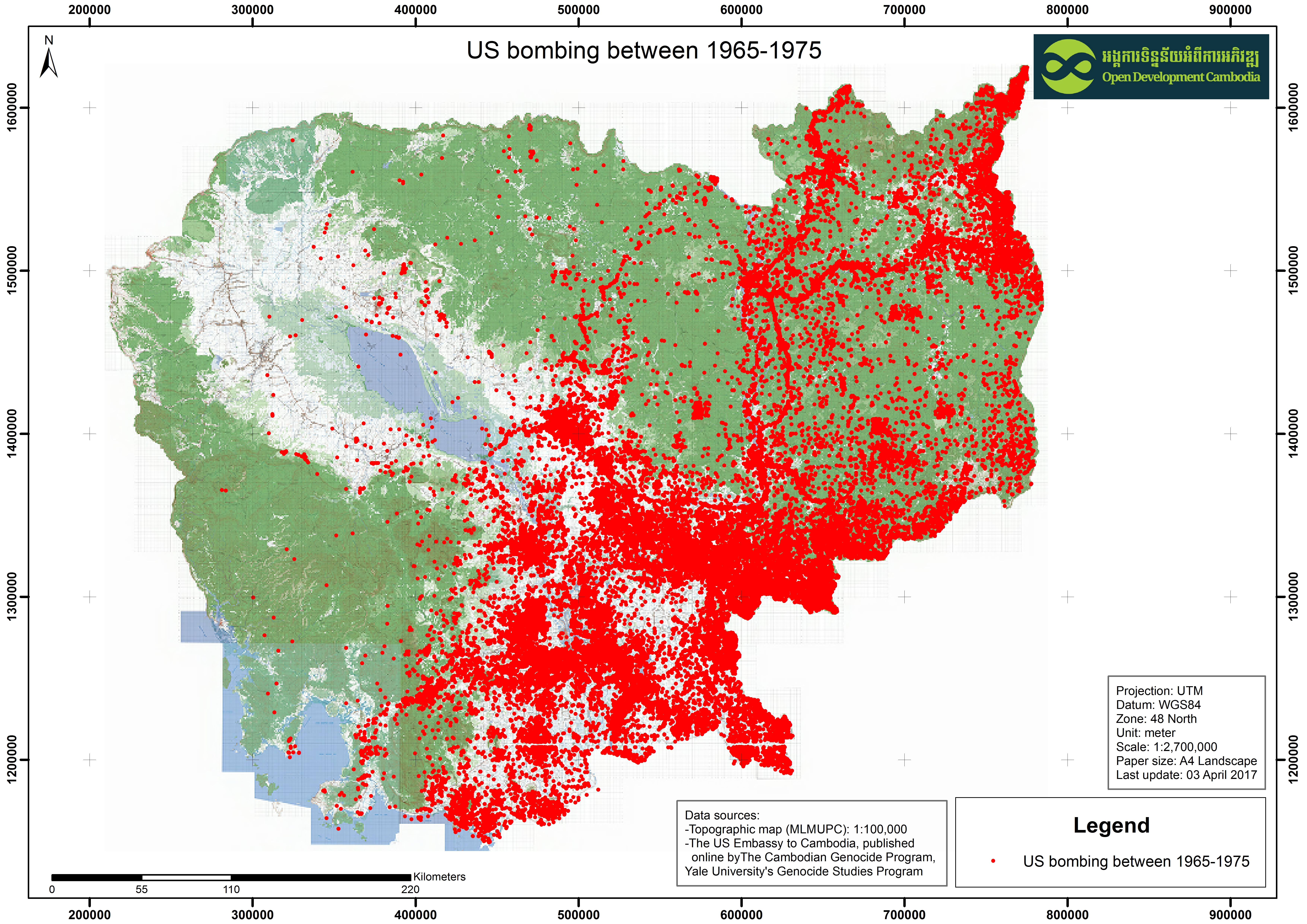
US bombing in Cambodia (1965-1975)
ຈັດພິມໂດຍ: Open Development Cambodia
ແຫຼ່ງຂໍ້ມູນ (7)
ເບິ່ງຕົວຢ່າງຂໍ້ມູນ - US bombing in Cambodia (1965-1975)
Additional Info
| Field | Value |
|---|---|
| ປະເພດຫົວຂໍ້ຊຸດຂໍ້ມູນ | Landmines UXO and demining |
| ພາສາ |
|
| ຂໍ້ຈຳກັດໃນການນຳໃຊ້ | By accessing this website or database, users agree to take full responsibility for reliance on any site information provided and to hold harmless and waive any and all liability against individuals or entities associated with its development, form and content for any loss, harm or damage suffered as a result of its use. |
| ວັນທີອ້າງອີງຂອງຊຸດຂໍ້ມູນ | 5 ມັງກອນ 2005 |
| ວັນທີເລີ່ມຕົ້ນການເກັບກຳຂໍ້ມູນ | 1 ຕຸລາ 1965 |
| ວັນທີສິ້ນສຸດການເກັບກຳຂໍ້ມູນ | 1 ພຶດສະພາ 1975 |
| ຊື່ທາງພູມສາດ |
|
| ຈຸດພິກັດຂອບເຂດເບື້ອງຕາເວັນຕົກ | 102.96825733734713 |
| ຈຸດພິກັດຂອບເຂດເບື້ອງຕາເວັນອອກ | 107.64089060993305 |
| ຈຸດພິກັດຂອບເຂດທາງທິດໃຕ້ | 10.414218753760217 |
| ຈຸດພິກັດຂອບເຂດທາງທິດເໜືອ | 14.696738322105572 |
| ລະບົບອ້າງອີງທີ່ຕັ້ງຈຸດພິກັດ | WGS 84 / UTM zone 48N (EPSG:32648) |
| ຄວາມຊັດເຈນດ້ານທີ່ຕັ້ງ | There is no issue with accuracy found |
| ຄວາມສອດຄ່ອງຕາມເຫດຜົນ | There is no issue with logical consistency found |
| ຄວາມສົມບູນຂອງຂໍ້ຊຸດມູນ | There is no issue with completeness found. |
| ຂັ້ນຕອນການປະມວນຂໍ້ມູນ | Map and Data team from Open Development Cambodia downloaded the data from the Center for Earth Observation (www.yale.edu/ceo) at the Yale Institute for Biospheric Studies (www.yale.edu/yibs) as ArcGIS Geodatabase. Then the team exported to various extention such as KML, SHP, GeoJSON and Spreadsheet and visualize on ODC interactive map. |
| ແຫຼ່ງທີ່ມາ | The US bombing database was released by the US Embassy in Cambodia to the Royal Cambodian Government and the Cambodian Mine Action Authority (CMAA) to assist in the clearance of unexploded ordnance. |
| ໜ່ວຍງານຮັບຜິດຊອບ | The Whitney and Betty MacMillan Center for International and Area Studies at Yale (Genocide Studies Program).P.O. Box 208206 New Haven, Connecticut, 06520-8206, USA U.S. Embassy Phnom Penh. #1, Street 96 Sangkat Wat Phnom, Khan Daun Penh, Phnom Penh. Phone: (855-23) 728-000 |
| ຂໍ້ມູນການສ້າງ metadata | Metadata last updated on 2017-04-3. For inquiries contact: Open Development Cambodia Address: #43, St. 208, Sangkat Boeung Riang, Khan Daun Penh, Phnom Penh, Cambodia. Tel: +855 23 221 164 Email: contact@opendevcam.net Website:https://cambodia.opendevelopmentmekong.net/ |
| ສັນຍາລິຂະສິດ | CC-BY-3.0-IGO |
| ລິຂະສິດ | Yes |
| ເວີຊັ້ນ | 1.0 |
| ວັນທີອັບໂຫຼດ | ເມສາ 3, 2017, 07:02 (UTC) |
| ວັນທີດັດແປງ | ຕຸລາ 8, 2019, 16:24 (UTC) |