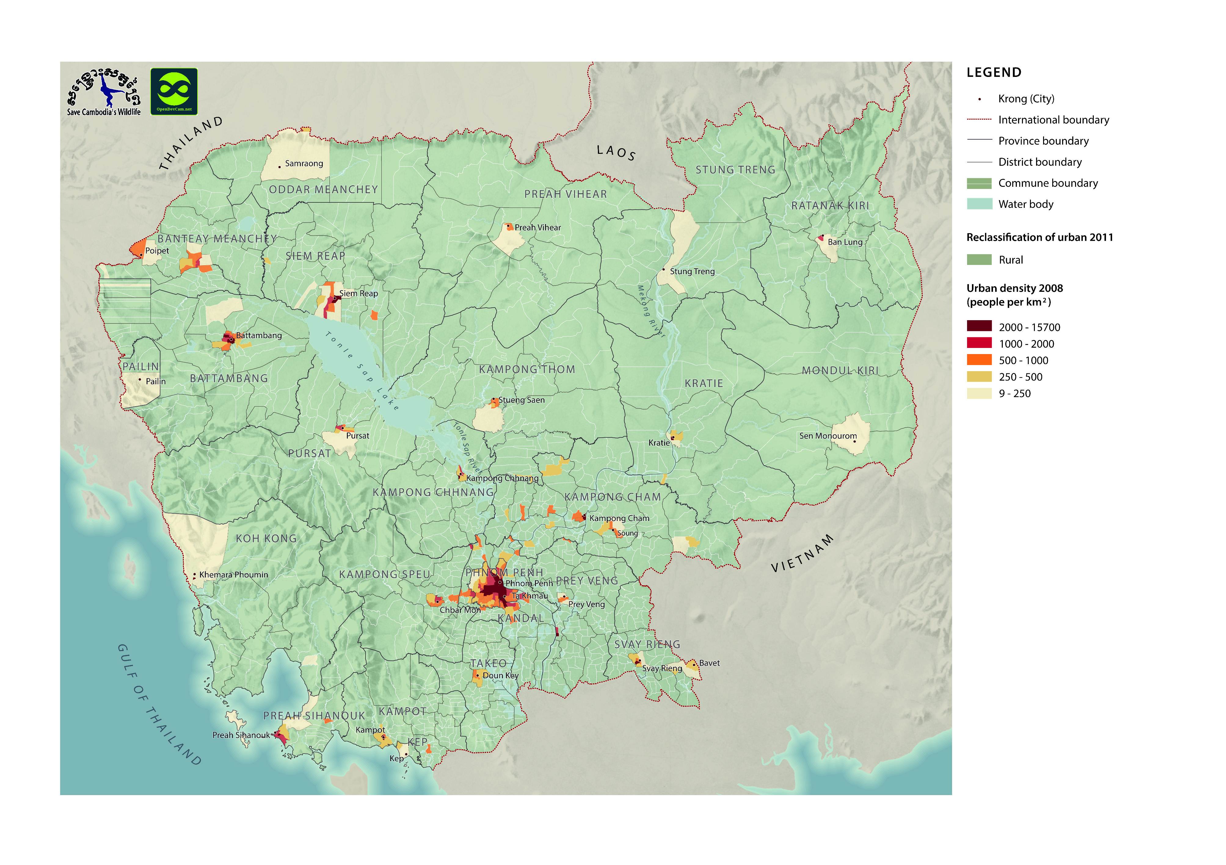
Urban density in Cambodia (2011)
ຈັດພິມໂດຍ: Open Development Cambodia
ແຫຼ່ງຂໍ້ມູນ (7)
ເບິ່ງຕົວຢ່າງຂໍ້ມູນ - Urban density in Cambodia (2011)
Additional Info
| Field | Value |
|---|---|
| ປະເພດຫົວຂໍ້ຊຸດຂໍ້ມູນ |
|
| ພາສາ |
|
| ວັນທີອ້າງອີງຂອງຊຸດຂໍ້ມູນ | 26 ກັນຍາ 11 |
| ວັນທີເລີ່ມຕົ້ນການເກັບກຳຂໍ້ມູນ | 5 ທັນວາ 2015 |
| ວັນທີສິ້ນສຸດການເກັບກຳຂໍ້ມູນ | 5 ທັນວາ 2015 |
| ຊື່ທາງພູມສາດ |
|
| ຈຸດພິກັດຂອບເຂດເບື້ອງຕາເວັນຕົກ | 102.3409141451868 |
| ຈຸດພິກັດຂອບເຂດເບື້ອງຕາເວັນອອກ | 107.30722699901682 |
| ຈຸດພິກັດຂອບເຂດທາງທິດໃຕ້ | 10.343718099475597 |
| ຈຸດພິກັດຂອບເຂດທາງທິດເໜືອ | 14.443950119711772 |
| ລະບົບອ້າງອີງທີ່ຕັ້ງຈຸດພິກັດ | WGS 84 / UTM zone 48N (EPSG:32648) |
| ຄວາມຊັດເຈນດ້ານທີ່ຕັ້ງ | There are no known issues with accuracy. |
| ຄວາມສອດຄ່ອງຕາມເຫດຜົນ | There are no known issues with logical consistency. |
| ຄວາມສົມບູນຂອງຂໍ້ຊຸດມູນ | There are no known issues with completeness. |
| ຂັ້ນຕອນການປະມວນຂໍ້ມູນ | Dataset were provided to Open Development Cambodia directly by Save Cambodia's Wildlife's 2013 Atlas Working Group in ESRI Shapefile format. The dataset were exported in GeoJSON, JPEG, KML and HTML format. |
| ແຫຼ່ງທີ່ມາ | Save Cambodia's Wildlife. "Urban Density." In Atlas of Cambodia: maps on socio-economic development and environment. Second ed. Phnom Penh, 2014. 98-99. Print. United Nations Population Fund. Reclassification of Urban Areas in Cambodia. 2011. |
| ໜ່ວຍງານຮັບຜິດຊອບ | Save Cambodia's Wildlife (SCW), info@cambodiaswildlife.org, +855 23 88 20 35, http://cambodiaswildlife.org, 6Eo St. 570, Sangkat Boeung Kak 2, Khan Tuol Kork, Phnom Penh, Cambodia |
| ລາຍການໃນຊຸດຂໍ້ມູນ | Province / Government of Cambodia : Province name, District/ Government of Cambodia : District name, Com_Code/ Government of Cambodia : Commune code, Commune/ Government of Cambodia : Commune name, TOTPOP/ Government of Cambodia : Total population, URBAN04 / United Nations Population Fund : Classified as urban in 2004 (U for urban, NU for non-urban), U_Den08 / United Nations Population Fund : Urban density in 2007 (people per square kilometer), URB_RC2011 / United Nations Population Fund, URB_RCSDC / United Nations Population Fund, U_Reclass / United Nations Population Fund, Male11 / United Nations Population Fund : Male population in 2011, Female11 / United Nations Population Fund : Female population in 2011, Family11 / United Nations Population Fund : Number of families in 2011, Den_2011 / United Nations Population Fund : Population density 2011 (people per square kilometer), TOPOP11 / United Nations Population Fund : Total population in 2011, TOT_Area_C / United Nations Population Fund : Area of Commune |
| ສັນຍາລິຂະສິດ | CC-BY-4.0 |
| ລິຂະສິດ | No |
| ເວີຊັ້ນ | 1.0 |
| ວັນທີອັບໂຫຼດ | ຕຸລາ 4, 2015, 21:02 (UTC) |
| ວັນທີດັດແປງ | ຕຸລາ 8, 2019, 18:42 (UTC) |