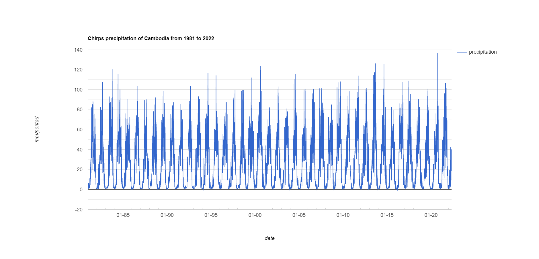
Rainfall estimates from rain gauge and satellite observations (CHIRPS pentad dataset)
ຈັດພິມໂດຍ: Open Development Cambodia
ແຫຼ່ງຂໍ້ມູນ (2)
ເບິ່ງຕົວຢ່າງຂໍ້ມູນ - CHIRPS pentad: Rainfall dataset (Chart)
Additional Info
| Field | Value |
|---|---|
| ປະເພດຫົວຂໍ້ຊຸດຂໍ້ມູນ |
|
| ພາສາ |
|
| ຂໍ້ຈຳກັດໃນການນຳໃຊ້ | By accessing this website or database, users agree to take full responsibility for reliance on any site information provided and to hold harmless and waive any and all liability against individuals or entities associated with its development, form and content for any loss, harm or damage suffered as a result of its use. |
| ວັນທີເລີ່ມຕົ້ນການເກັບກຳຂໍ້ມູນ | 1 ມັງກອນ 1981 |
| ວັນທີສິ້ນສຸດການເກັບກຳຂໍ້ມູນ | 30 ເມສາ 2022 |
| ຊື່ທາງພູມສາດ |
|
| ຈຸດພິກັດຂອບເຂດເບື້ອງຕາເວັນຕົກ | 102.54859870122804 |
| ຈຸດພິກັດຂອບເຂດເບື້ອງຕາເວັນອອກ | 107.38900215119163 |
| ຈຸດພິກັດຂອບເຂດທາງທິດໃຕ້ | 10.496327885971324 |
| ຈຸດພິກັດຂອບເຂດທາງທິດເໜືອ | 14.344214200747942 |
| ຄວາມຊັດເຈນດ້ານທີ່ຕັ້ງ | CHIRPS pentad can derive from https://chc.ucsb.edu/data/chirps or https://code.earthengine.google.com/?scriptPath=Examples:Datasets/UCSB-CHG_CHIRPS_PENTAD |
| ຄວາມຊັດເຈນຂອງລາຍການຊຸດຂໍ້ມູນ | There are no known issues with attribute accuracy. |
| ຄວາມສອດຄ່ອງຕາມເຫດຜົນ | There are no known issues with logical consistency. |
| ຂັ້ນຕອນການປະມວນຂໍ້ມູນ | The data comes from the big dataset of the Google Earth Engine platform. Javascript code was utilized in the Google Earth Engine, clipped with Cambodia's boundary, and exported through user Google Drive. |
| ແຫຼ່ງທີ່ມາ | The data is derived from https://code.earthengine.google.com/?scriptPath=Examples:Datasets/UCSB-CHG_CHIRPS_PENTAD |
| ໜ່ວຍງານຮັບຜິດຊອບ | Climate Hazards Center UC Santa Barbara Santa Barbara, CA 93106 |
| ຂໍ້ມູນການສ້າງ metadata | Metadata last updated on 2022-06-23. For inquiries contact: Open Development Cambodia, Email: contact@opendevcam.net, Website: http://www.opendevcam.net Address: 23B St. 606, Phnom Penh, Cambodia. |
| ສັນຍາລິຂະສິດ |
No license given |
| ລິຂະສິດ | Yes |
| ເວີຊັ້ນ | 1 |
| ຄຳສັບຫຼັກ | CHIRPS pentad,Rainfall |
| ວັນທີອັບໂຫຼດ | ພຶດສະພາ 30, 2022, 08:20 (UTC) |
| ວັນທີດັດແປງ | ມິຖຸນາ 23, 2022, 09:16 (UTC) |