Mine/ERW casualties (2005- 2013)
ຈັດພິມໂດຍ: Open Development Cambodia
ແຫຼ່ງຂໍ້ມູນ (8)
ເບິ່ງຕົວຢ່າງຂໍ້ມູນ - Mine/ERW casualties (2005- 2013)
Additional Info
| Field | Value |
|---|---|
| ປະເພດຫົວຂໍ້ຊຸດຂໍ້ມູນ |
|
| ພາສາ |
|
| ຂໍ້ຈຳກັດໃນການນຳໃຊ້ | By accessing this website or database, users agree to take full responsibility for reliance on any site information provided and to hold harmless and waive any and all liability against individuals or entities associated with its development, form and content for any loss, harm or damage suffered as a result of its use. |
| ວັນທີອ້າງອີງຂອງຊຸດຂໍ້ມູນ | 1 ມັງກອນ 2013 |
| ວັນທີເລີ່ມຕົ້ນການເກັບກຳຂໍ້ມູນ | 1 ມັງກອນ 2005 |
| ວັນທີສິ້ນສຸດການເກັບກຳຂໍ້ມູນ | 1 ມັງກອນ 2013 |
| ຊື່ທາງພູມສາດ |
|
| ຈຸດພິກັດຂອບເຂດເບື້ອງຕາເວັນຕົກ | 102.336029052734 |
| ຈຸດພິກັດຂອບເຂດເບື້ອງຕາເວັນອອກ | 107.443817138672 |
| ຈຸດພິກັດຂອບເຂດທາງທິດໃຕ້ | 10.4554433822632 |
| ຈຸດພິກັດຂອບເຂດທາງທິດເໜືອ | 14.4457607269287 |
| ລະບົບອ້າງອີງທີ່ຕັ້ງຈຸດພິກັດ | WGS 84 (EPSG:4326) (CRS:84) |
| ຄວາມຊັດເຈນດ້ານທີ່ຕັ້ງ | The baseline data was collected from OCHA website, and ODC cannot guarantee for its accuracy. |
| ຂັ້ນຕອນການປະມວນຂໍ້ມູນ | Open Development Cambodia (ODC) downloaded the data from HDX (https://data.humdata.org) as ESRI shapefile. In addition to the existing file format, ODC's map and data team also created three more additional extensions: CSV, GeoJSON and KML for download. The team used CartoDB to make the data visualization layer and added the result onto ODC map explorerhttps://opendevelopmentcambodia.net/map-explorer. |
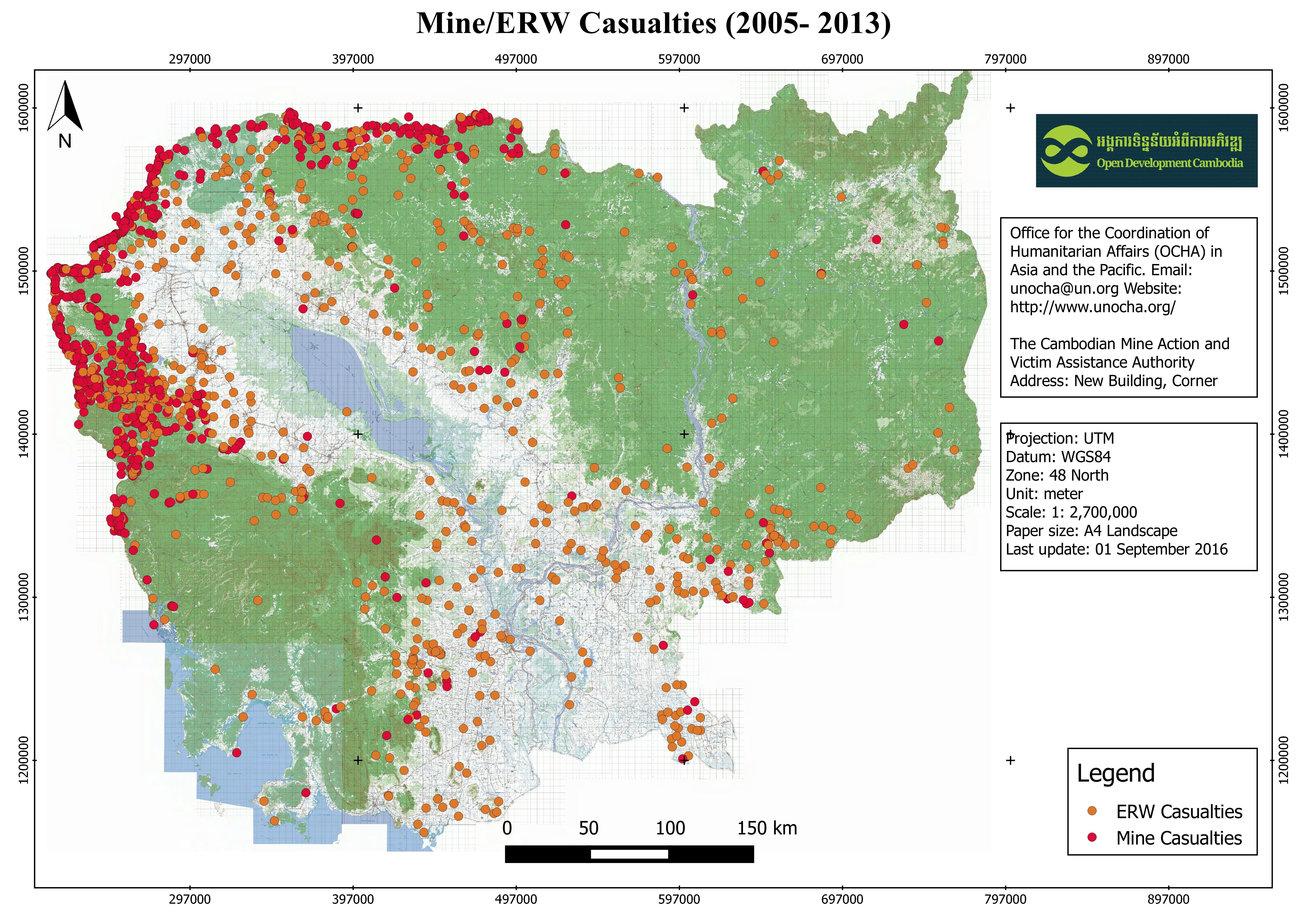
| ແຫຼ່ງທີ່ມາ | Office for the Coordination of Humanitarian Affairs (OCHA) in Asia and the Pacific. Email: unocha@un.org Website: http://www.unocha.org/ The Cambodian Mine Action and Victim Assistance Authority Address: New Building, Corner Street 273 & 516, Tuol Kork Village, Tuol Sangke Quarter, Phnom Penh, Cambodia Phone / Fax: (+855) 23 880 462/ 228 265, E-mail: info@cmaa.gov.kh, Website: www.cmaa.gov.kh |
| ໜ່ວຍງານຮັບຜິດຊອບ | Humanitarian Data Exchange (HDX) Email: hdx@un.org . Website: https://data.humdata.org/ |
| ຂໍ້ມູນການສ້າງ metadata | Metadata last updated on 2016-09-27. For inquiries contact: Open Development Cambodia (ODC). Address: #43 St. 208, Phnom Penh, Cambodia. Email: contact@opendevcam.net Website: http://www.opendevcam.net |
| ລາຍການໃນຊຸດຂໍ້ມູນ | Incident_D :Incident date, ProvCode: Province code, Province: Name of province, DisCode: District code, District: District code, ComCode: Commune code, Commune: Name of commune, VilCode: Village Code, Village: Name of village, Landuse: Type of mine on land use, VICTIM: Number of victim, INJURE : Number of injured, AMPUTATION : Number of amputation, KILLED: Number of killed, DEVICES: Device of explosion, ERW_TYPE: ERW Type, MINE_TYPE: Type of mine |
| ສັນຍາລິຂະສິດ | Creative Commons Attribution |
| ລິຂະສິດ | Yes |
| ເວີຊັ້ນ | 1.0 |
| ວັນທີອັບໂຫຼດ | ຕຸລາ 19, 2016, 01:51 (UTC) |
| ວັນທີດັດແປງ | ມິຖຸນາ 30, 2020, 16:44 (UTC) |