| ປະເພດຫົວຂໍ້ຊຸດຂໍ້ມູນ |
- Forest classifications
- Forest cover
- Forest protection
- Forests and forestry
|
| ພາສາ |
|
| ຂໍ້ຈຳກັດໃນການນຳໃຊ້ |
By accessing this website or database, users agree to take full responsibility for reliance on any site information provided and to hold harmless and waive any and all liability against individuals or entities associated with its development, form and content for any loss, harm or damage suffered as a result of its use.
|
| ວັນທີອ້າງອີງຂອງຊຸດຂໍ້ມູນ |
1 ມັງກອນ 2007
|
| ວັນທີເລີ່ມຕົ້ນການເກັບກຳຂໍ້ມູນ |
1 ມັງກອນ 1973
|
| ວັນທີສິ້ນສຸດການເກັບກຳຂໍ້ມູນ |
2 ມັງກອນ 2014
|
| ຊື່ທາງພູມສາດ |
|
| ຈຸດພິກັດຂອບເຂດເບື້ອງຕາເວັນຕົກ |
102.32051817855546 |
| ຈຸດພິກັດຂອບເຂດເບື້ອງຕາເວັນອອກ |
107.6427557748046 |
| ຈຸດພິກັດຂອບເຂດທາງທິດໃຕ້ |
10.343517951874727 |
| ຈຸດພິກັດຂອບເຂດທາງທິດເໜືອ |
14.704161720274232 |
| ລະບົບອ້າງອີງທີ່ຕັ້ງຈຸດພິກັດ |
WGS 84 / UTM zone 48N (EPSG:32648) |
| ຄວາມຊັດເຈນດ້ານທີ່ຕັ້ງ |
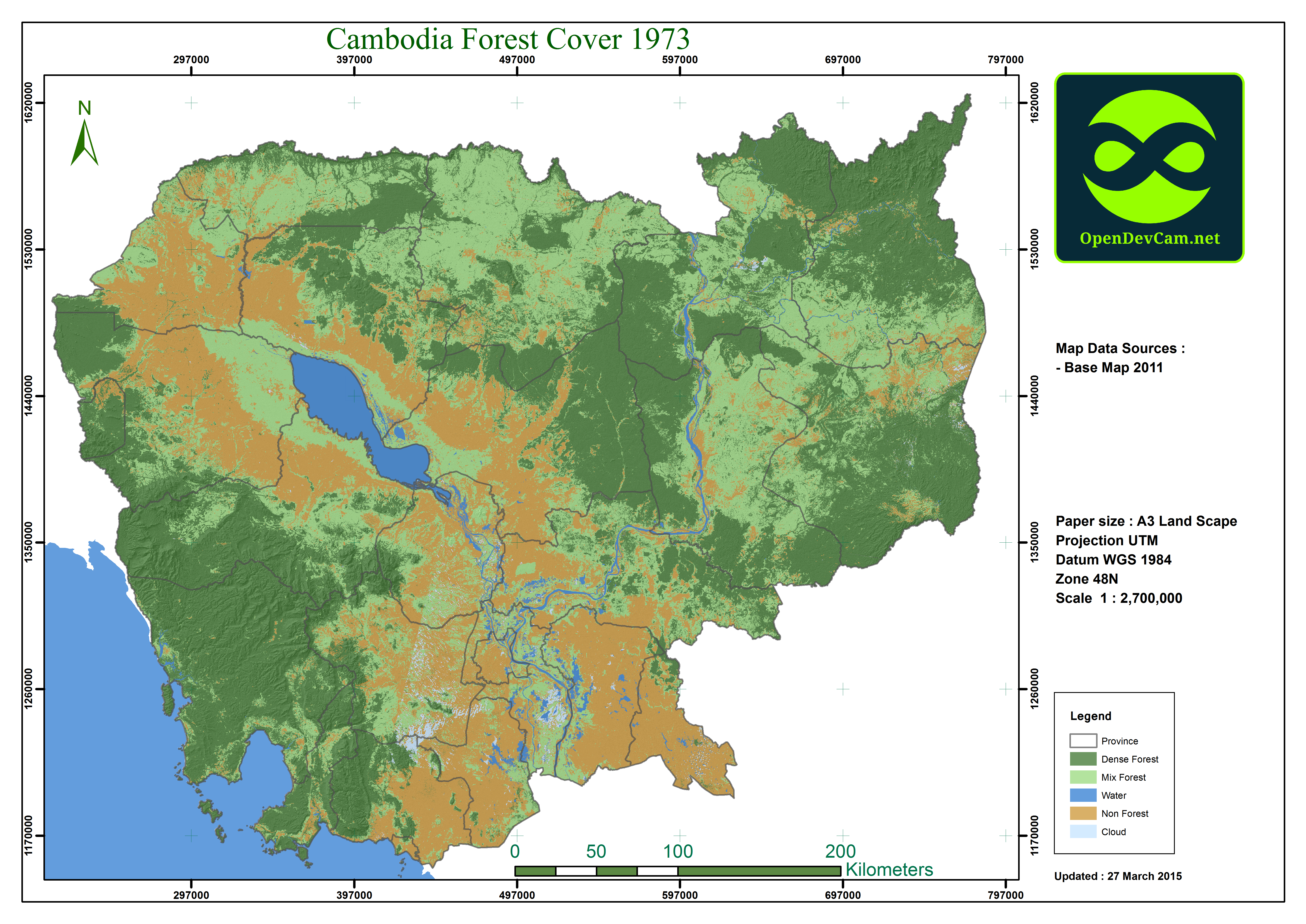
The 1973 images had a 60m resolution while the 1989, 2000, 2004, 2009 and 2014 images had a 30m resolution. Since the maps are based on satellite images with a resolution of either 60 meters or 30 meters, it was not possible to differentiate the specific tree species that comprise the forests. The image classification method used to create these trend maps does not include ground truthing. (See the Limitations section on ODC Forest Cover page for more information: http://www.opendevelopmentcambodia.net/briefings/forest-cover/)
|
| ຄວາມສອດຄ່ອງຕາມເຫດຜົນ |
Supervised classification using 30m resolution cannot distinguish crop or plantation areas from mixed forest. Cambodian topography and seasonality of images also contributed to this inconsistency. The calculation of forest cover is determined by forest definition. ODC follows the definition of Forestry Administration’s Cambodia Forest Cover publication dated June 2008. Different studies use different definitions and thus yield different results. (section on ODC Forest Cover page for more information: http://www.opendevelopmentcambodia.net/briefings/forest-cover/).
|
| ຄວາມສົມບູນຂອງຂໍ້ຊຸດມູນ |
There are no know issues with completeness
|
| ຂັ້ນຕອນການປະມວນຂໍ້ມູນ |
Data were downloaded from USGS directly by Open Development Cambodia, and ODC mappers have processed that raw imagery without any image referencing, atmospheric or topographic correction. The only technical the mappers applied is to enhance imagery for making eye-interpretation easy to choose the training sampling sites and band selected for high forest reflection through technical advised from ODC\2019s external consultant professor at Vietnam Can Tho University.The forest cover map for each year was made from 16 to 19 satellite images. The earliest images available for Cambodia date from the early 1970s. Most recent images are obtained from the USGS website in February 2014. ODC selected satellite images for analysis from 1973, 1989, 2000, 2004, 2009, and 2014 based on their quality, particularly the absence of cloud cover. Classification of ground cover is limited to dense forest, mixed forest, water, non forest and cloud. These 5 classes were derived from Multispectral Scanner (MSS), Thematic Mapper (TM), Enhanced Thematic Mapper Plus (ETM+) and Operational Land Imager (OLI) through Maximum Likelihood methodology. ODC applied atmospheric correction to the 2014 images. However, ODC was unable to apply more precise methods of classification, such as the decision tree methodology applied by Hansen et al in the University of Maryland study, due to the resources required for this methodology. (see Methods for more information)
|
| ແຫຼ່ງທີ່ມາ |
U.S. Department of the Interior, United States Geological Survey (USGS). 2014. http://earthexplorer.usgs.gov. Contact email: http://answers.usgs.gov/cgi-bin/gsanswers?tmplt=2 +1 888 275 8747 http://www.usgs.gov Reston, United States
|
| ໜ່ວຍງານຮັບຜິດຊອບ |
United States Geological Survey (USGS) Contact email: http://answers.usgs.gov/cgi-bin/gsanswers?tmplt=2 +1 888 275 8747 http://www.usgs.gov Reston, United States
|
| ຂໍ້ມູນການສ້າງ metadata |
Metadata last updated on 2015-03-17. For inquiries contact: Open Development Cambodia contact@opendevcam.net +855 23 221 164 http://www.opendevcam.net 43 St. 208, Sangkat Boeung Riang, Khan Daun Penh, Phnom Penh, Cambodia.
|
| ລາຍການໃນຊຸດຂໍ້ມູນ |
Value/ODC: Raster value, which are divided into five categories: 1: dense forest, 2: mixed forest, 3: water, 4: non-forest and, 5: cloud. Count/ODC: Pixel
|
| ສັນຍາລິຂະສິດ |
CC-BY-SA-4.0
|
| ລິຂະສິດ |
Yes |
| ເວີຊັ້ນ |
1.0 |
| ຄຳສັບຫຼັກ |
Forest |
| ວັນທີອັບໂຫຼດ |
ພະຈິກ 25, 2015, 14:49 (UTC)
|
| ວັນທີດັດແປງ |
ມິຖຸນາ 24, 2020, 04:16 (UTC)
|