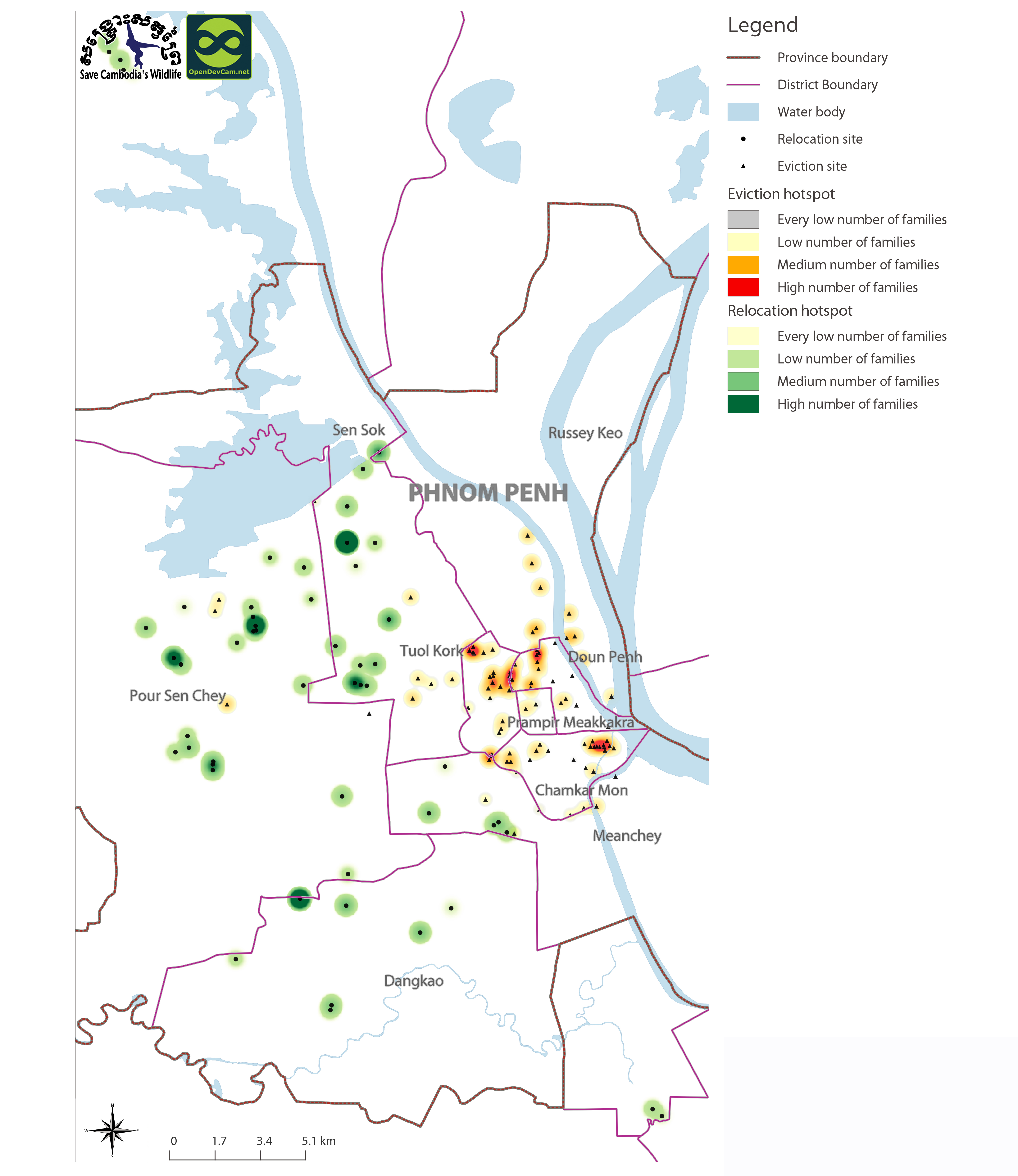
Eviction and relocation hotspots in Cambodia (2013)
ຈັດພິມໂດຍ: Open Development Cambodia
ແຫຼ່ງຂໍ້ມູນ (11)
ເບິ່ງຕົວຢ່າງຂໍ້ມູນ - Eviction and relocation hotspots in Cambodia (2013)
Additional Info
| Field | Value |
|---|---|
| ປະເພດຫົວຂໍ້ຊຸດຂໍ້ມູນ |
|
| ພາສາ |
|
| ຂໍ້ຈຳກັດໃນການນຳໃຊ້ | By accessing this website or database, users agree to take full responsibility for reliance on any site information provided and to hold harmless and waive any and all liability against individuals or entities associated with its development, form and content for any loss, harm or damage suffered as a result of its use. |
| ວັນທີອ້າງອີງຂອງຊຸດຂໍ້ມູນ | 1 ຕຸລາ 13 |
| ຊື່ທາງພູມສາດ |
|
| ຈຸດພິກັດຂອບເຂດເບື້ອງຕາເວັນຕົກ | 104.79792041689095 |
| ຈຸດພິກັດຂອບເຂດເບື້ອງຕາເວັນອອກ | 104.94528117850643 |
| ຈຸດພິກັດຂອບເຂດທາງທິດໃຕ້ | 11.517529321828004 |
| ຈຸດພິກັດຂອບເຂດທາງທິດເໜືອ | 11.639773997653371 |
| ລະບົບອ້າງອີງທີ່ຕັ້ງຈຸດພິກັດ | WGS 84 / UTM zone 48N (EPSG:32648) |
| ຄວາມຊັດເຈນດ້ານທີ່ຕັ້ງ | There are no known issues with accuracy. |
| ຄວາມສອດຄ່ອງຕາມເຫດຜົນ | There are no known issues with logical consistency. |
| ຄວາມສົມບູນຂອງຂໍ້ຊຸດມູນ | There are no known issues with completeness. |
| ຂັ້ນຕອນການປະມວນຂໍ້ມູນ | Data were provided to Open Development Cambodia directly by Save Cambodia's Wildlife's 2013 Atlas Working Group in ESRI Shapefile format. The coordinate reference system was changed from WGS 84 Zone 48 N to WGS 84 and the data was exported in both ESRI Shapefile and geoJSON formats. |
| ແຫຼ່ງທີ່ມາ | Sahmakum Teang Tnaut and Save Cambodia's Wildlife. Atlas of Cambodia: maps on socio-economic development and environment. Second ed. Phnom Penh, 2014. Print. |
| ໜ່ວຍງານຮັບຜິດຊອບ | Sahmakum Teang Tnaut info@teangtnaut.org, Save Cambodia's Wildlife (SCW), info@cambodiaswildlife.org, +855 23 88 20 35, http://cambodiaswildlife.org, 6Eo St. 570, Sangkat Boeung Kak 2, Khan Tuol Kork, Phnom Penh, Cambodia. |
| ຂໍ້ມູນການສ້າງ metadata | Metadata last updated on 2014-06-19. For inquiries contact: Loch Kalyan, Open Development Cambodia, contact@opendevcam.net, +855 23 221 164, http://www.opendevelopmentcambodia.net, 43 St. 208, Sangkat Boeung Riang, Khan Daun Penh, Phnom Penh, Cambodia. |
| ລາຍການໃນຊຸດຂໍ້ມູນ | Raster value/Sahmakum Teang Tnaut: Number of families. The levels are high, medium, low and very low. |
| ສັນຍາລິຂະສິດ | CC-BY-SA-4.0 |
| ລິຂະສິດ | Yes |
| ເວີຊັ້ນ | 1.0 |
| ຄຳສັບຫຼັກ | Eviction and relocation hotspots |
| ວັນທີອັບໂຫຼດ | ຕຸລາ 4, 2015, 21:01 (UTC) |
| ວັນທີດັດແປງ | ຕຸລາ 8, 2019, 18:44 (UTC) |