Economic corridors of Cambodia
ຈັດພິມໂດຍ: Open Development Cambodia
ແຫຼ່ງຂໍ້ມູນ (6)
ເບິ່ງຕົວຢ່າງຂໍ້ມູນ - Economic corridors of Cambodia
Additional Info
| Field | Value |
|---|---|
| ປະເພດຫົວຂໍ້ຊຸດຂໍ້ມູນ |
|
| ພາສາ |
|
| ຂໍ້ຈຳກັດໃນການນຳໃຊ້ | No access and use constraints. |
| ວັນທີອ້າງອີງຂອງຊຸດຂໍ້ມູນ | 2 ມັງກອນ 2012 |
| ຊື່ທາງພູມສາດ |
|
| ຈຸດພິກັດຂອບເຂດເບື້ອງຕາເວັນຕົກ | 102.551300048828 |
| ຈຸດພິກັດຂອບເຂດເບື້ອງຕາເວັນອອກ | 107.504234313965 |
| ຈຸດພິກັດຂອບເຂດທາງທິດໃຕ້ | 10.4262790679932 |
| ຈຸດພິກັດຂອບເຂດທາງທິດເໜືອ | 13.9100093841553 |
| ລະບົບອ້າງອີງທີ່ຕັ້ງຈຸດພິກັດ | WGS 84 (EPSG:4326) (CRS:84) |
| ຄວາມຊັດເຈນດ້ານທີ່ຕັ້ງ | |
| ຄວາມສອດຄ່ອງຕາມເຫດຜົນ | |
| ຄວາມສົມບູນຂອງຂໍ້ຊຸດມູນ | |
| ຂັ້ນຕອນການປະມວນຂໍ້ມູນ | The data was visualized in CartoDB and created a custom legend and information windows for data points. Subsets of this data were created for presentation at country level. |
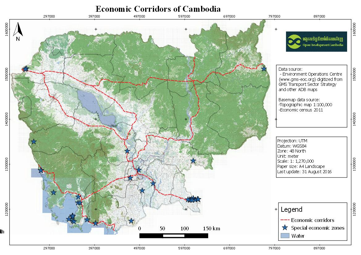
| ແຫຼ່ງທີ່ມາ | Environment Operations Centre (www.gms-eoc.org) digitized from GMS Transport Sector Strategy and other ADB maps. |
| ໜ່ວຍງານຮັບຜິດຊອບ | |
| ຂໍ້ມູນການສ້າງ metadata | Metadata last updated on 2016-05-31. For inquiries contact: Open Development Cambodia Address: #43 St. 208, Phnom Penh, Cambodia. Email: contact@opendevcam.net Website: http://www.opendevcam.net |
| ລາຍການໃນຊຸດຂໍ້ມູນ | |
| ສັນຍາລິຂະສິດ | unspecified |
| ລິຂະສິດ | Unclear copyright |
| ເວີຊັ້ນ | 1.0 |
| ວັນທີອັບໂຫຼດ | ກໍລະກົດ 14, 2015, 10:34 (UTC) |
| ວັນທີດັດແປງ | ຕຸລາ 8, 2019, 16:25 (UTC) |