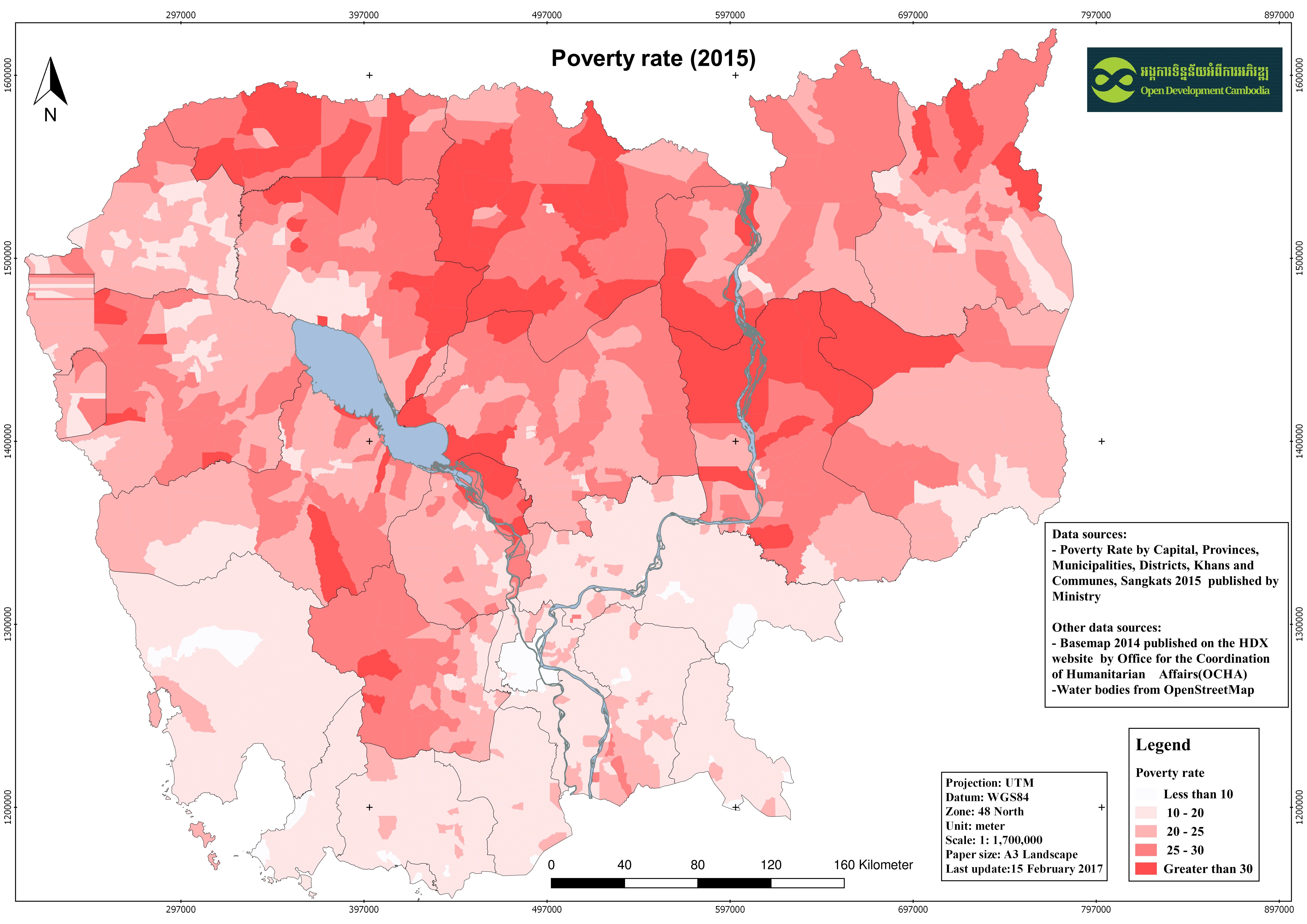
Cambodian population and poverty rate 2015
ຈັດພິມໂດຍ: Open Development Cambodia
ແຫຼ່ງຂໍ້ມູນ (7)
ເບິ່ງຕົວຢ່າງຂໍ້ມູນ - Cambodian population and poverty rate 2015
Additional Info
| Field | Value |
|---|---|
| ປະເພດຫົວຂໍ້ຊຸດຂໍ້ມູນ |
|
| ພາສາ |
|
| ຂໍ້ຈຳກັດໃນການນຳໃຊ້ | By accessing this website or database, users agree to take full responsibility for reliance on any site information provided and to hold harmless and waive any and all liability against individuals or entities associated with its development, form and content for any loss, harm or damage suffered as a result of its use. |
| ວັນທີອ້າງອີງຂອງຊຸດຂໍ້ມູນ | 23 ມັງກອນ 2017 |
| ຊື່ທາງພູມສາດ |
|
| ຈຸດພິກັດຂອບເຂດເບື້ອງຕາເວັນຕົກ | 102.32040017933838 |
| ຈຸດພິກັດຂອບເຂດເບື້ອງຕາເວັນອອກ | 107.6427929109558 |
| ຈຸດພິກັດຂອບເຂດທາງທິດໃຕ້ | 10.34357826058839 |
| ຈຸດພິກັດຂອບເຂດທາງທິດເໜືອ | 14.704156340453409 |
| ລະບົບອ້າງອີງທີ່ຕັ້ງຈຸດພິກັດ | WGS 84 / UTM zone 48N (EPSG:32648) |
| ຄວາມຊັດເຈນດ້ານທີ່ຕັ້ງ | There are no known about the issues of accuracy. |
| ຄວາມສອດຄ່ອງຕາມເຫດຜົນ | There are no known issues with logical consistency. |
| ຄວາມສົມບູນຂອງຂໍ້ຊຸດມູນ | There are no known issues with completeness. |
| ຂັ້ນຕອນການປະມວນຂໍ້ມູນ | ODC Map and Data team downloaded the non-spatial data from website of Ministry of Planning in PDF format then coveted and clean it to excel format as the attribute information for the shapefile. After that the excel file was join with the shapefile of Cambodia basemap 2014 which was published on Humanitarian Data Exchange (HDX). The result of the join was converted for various extension such as GeoJson, KML, JPEG, and spreadsheet |
| ແຫຼ່ງທີ່ມາ | -Ministry of Planning of Cambodia: www.mop.gov.kh/ -Humanitarian Data Exchange (HDX): https://data.humdata.org |
| ໜ່ວຍງານຮັບຜິດຊອບ | For non-spatial data: - Ministry of Planning Address: 386 Monivong Boulevard, Phnom Penh Postal Code: 12302 Phone: 023 720 901 For spatial data: - Humanitarian Data Exchange (HDE) Email: hdx@un.org. Website: https://data.humdata.org/ |
| ຂໍ້ມູນການສ້າງ metadata | Metadata last updated on 2017-01-23. For inquiries contact: Open Development Cambodia (ODC). Address: #43 St. 208, Sangkat Boeung Raing, Khan Daun Penh, Phnom Penh, Cambodia. Email: contact@opendevcam.net Website: https://opendevelopmentcambodia.net |
| ລາຍການໃນຊຸດຂໍ້ມູນ | tot_pop: total population;tot_family: total family;pov_rate:poverty rate |
| ສັນຍາລິຂະສິດ | CC-BY-SA-4.0 |
| ລິຂະສິດ | Yes |
| ເວີຊັ້ນ | 1.0 |
| ວັນທີອັບໂຫຼດ | ມັງກອນ 23, 2017, 03:08 (UTC) |
| ວັນທີດັດແປງ | ມິຖຸນາ 11, 2020, 04:02 (UTC) |