-
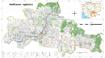
AidData’s Chinese Official Finance in Three Ecologically Sensitive Areas, Level 1, Version 1.01
 Cambodia, Lao People's Democratic Republic, Myanmar, Thailand, Viet Nam
January 31, 2017
Source: BenYishay, Ariel, Bradley Parks, Daniel Runfola, Rachel Trichler....
This is the 1.0.1 version of the Level 1 product, of a sub-nationally georeferenced dataset of Chinese official finance activities between 2000 and 2014 in three ecologically se...
Cambodia, Lao People's Democratic Republic, Myanmar, Thailand, Viet Nam
January 31, 2017
Source: BenYishay, Ariel, Bradley Parks, Daniel Runfola, Rachel Trichler....
This is the 1.0.1 version of the Level 1 product, of a sub-nationally georeferenced dataset of Chinese official finance activities between 2000 and 2014 in three ecologically se...
-
Airports of Vietnam
Viet Nam
July 1, 2016
Source: Global Map of Vietnam ©ISCGM/ Department of Survey and Mapping,...
A geospatial point dataset containing all known airports in Vietnam. It contains geospatial coordinates, object code, name, city, type, ICAO and IATA code .
-
Road and railway networks and market density
Cambodia
October 4, 2015
Source: Save Cambodia's Wildlife. Atlas of Cambodia: maps on...
 The Commune Database is produced by the NCDD (National Committee for Subnational Democratic Development). This file contains excerpts of the Database, namely the road and railwa...
-
Railway station of Vietnam
Viet Nam
July 1, 2016
Source: Global Map of Vietnam ©ISCGM/ Department of Survey and Mapping,...
A geospatial point dataset containing all known railway stations in Vietnam. It contains geospatial coordinates, object code, station's name.
-
Pursat communal land use planning (CLUP) atlas 2009
Cambodia
April 18, 2017
Source: Ministry of Land Management, Urban Planning and Construction...
 Pursat communal land use planning(CLUP) atlas (Chamraeun Phal, Kbal Trach, Me Tuek, Phteah Rung, Prongil, Roleab, Ta Lou, Tnaot Chum commune) is communal land use planning extra...
-
Koh Kong communal land use planning (CLUP) atlas 2009
Cambodia
April 18, 2017
Source: Ministry of Land Management, Urban Planning and Construction...
 Koh Kong communal land use planning(CLUP) atlas (Andong Tuek, Chrouy Pras, Smach Mean Chey, Stung Veng, Tma Sa, and Trapeang Rung commune) is communal land use planning extracte...
-
Ratanakiri communal land use planning (CLUP) atlas 2009
Cambodia
April 18, 2017
Source: Ministry of Land Management, Urban Planning and Construction...
 Ratanakiri communal land use planning(CLUP) atlas (Aekakpheap, Ka Choun, Pong, Sameaki, Serei Mongkol, and Toen commune) is communal land use planning extracted from 2009 contai...
-
Siem Reap communal land use planning (CLUP) atlas 2009
Cambodia
April 18, 2017
Source: Ministry of Land Management, Urban Planning and Construction...
 Siem Reap communal land use planning(CLUP) atlas (Chan Sar, Doun Peaeng, Leang Dai, Nokor Pheas , Popel, Srae Khvav, Svay Chek, Tayaek commune) is communal land use planning ext...
-
Kampong Speu commune land use planning (CLUP) atlas 2009
Cambodia
March 29, 2017
Source: Ministry of Land Management, Urban Planning and Construction...
Kampong Speu commune land use planning(CLUP) atlas (Kiri Vaon, Moha Sang, Honorom, Prabei Mom, Prey Khmeng, and Yea Angk commune) is communal land use planning extracted from 20...
-
Kampong Cham communal land use planning (CLUP) atlas 2009
Cambodia
April 18, 2017
Source: Ministry of Land Management, Urban Planning and Construction...
 Kampong Cham communal land use planning(CLUP) atlas (Chikor, Moung Riev, Roang, and Srak commune) is communal land use planning extracted from 2009 contained both detailed curre...
-
Mondulkiri communal land use planning (CLUP) atlas 2009
Cambodia
April 18, 2017
Source: Ministry of Land Management, Urban Planning and Construction...
 Mondulkiri communal land use planning(CLUP) atlas (Dak Dam, Pu Chri, Saen Monourom, Srae Ampum, Srae Khtum, and Srae Preah commune) is communal land use planning extracted from ...
-
Preah Sihanouk communal land use planning (CLUP) atlas 2009
Cambodia
April 18, 2017
Source: Ministry of Land Management, Urban Planning and Construction...
Preah Sihanouk communal land use planning(CLUP) atlas (Angdoung Thma, Kampenh, Outreh, Samrong, and Tomnob Rolok commune) is communal land use planning extracted from 2009 conta...
-
Kep communal land use planning (CLUP) atlas 2009
Cambodia
April 18, 2017
Source: Ministry of Land Management, Urban Planning and Construction...
Kep communal land use planning(CLUP) atlas (Angkaol, Ou Krasar, and Pong Tuek commune) is communal land use planning extracted from 2009 contained both detailed current land us...
-
Kratie communal land use planning (CLUP) atlas 2009
Cambodia
April 18, 2017
Source: Ministry of Land Management, Urban Planning and Construction...
 Kratie communal land use planning(CLUP) atlas (Dar, Kbal Damrey, O Krieng, Ruessei Kaev, Saob, Srae Char, Svay Chreah, and Thmi commune) is communal land use planning extracted ...
-
Urban design principles for flood resilience: Learning from the ecological wisdom of living with floods in the Vietnamese Mekong Delta
Viet Nam
December 29, 2017
Source: Kuei-Hsien Liao, Tuan Anh Le, Kien Van Nguyen (2016). Urban design...
Despite the widespread implementation of flood control infrastructure, modern cities around the world remain vulnerable to flood hazards. Although flood management has in genera...
-
Infrastructure investment needs in the Lower Mekong 2010-2020
Cambodia, Lao People's Democratic Republic, Myanmar, Thailand, Viet Nam
April 16, 2016
Source: Asian Development Bank Institute, Working Paper No....
Dataset created from an ADB Institute document to show the annual infrastructure investment required for each Lower Mekong country from 2010-2020. It also indicates the percenta...
-
Greater Mekong Subregion Economic Corridors 2012
Cambodia, China, Lao People's Democratic Republic, Myanmar, Thailand, Viet Nam
July 9, 2015
Source: Asian Development Bank / Environment Operations Center...
A dataset containing trans-boundary roads declared Greater Mekong Subregion transport corridors and their status as of 2012 -- existing, planned, potential.
-
ADB infrastructure-related projects 2005-2015
Cambodia, Lao People's Democratic Republic, Myanmar, Thailand, Viet Nam
April 16, 2016
Source: Asian Development Bank. Project Records.
http://www.adb.org/projects/
A summary of the number of infrastructure related projects approved by the ADB in Lower Mekong countries from 2005-2015. Collated for an interactive visualization on the OD Meko...
-
Airports of Myanmar
Myanmar
July 27, 2015
Source: Environment Operations Centre (www.gms-eoc.org) based on Open...
Airport locations in Myanmar including attributes (name, type ICAO and IATA code).