-
Tree cover loss by dominant driver

 Cambodia
April 9, 2026
Source: Global Forest Watch:...
Cambodia
April 9, 2026
Source: Global Forest Watch:...
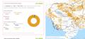 This dataset contained information about tree cover loss by the dominant driver in Cambodia from 2001 to 2024. The data were downloaded from Global Forest Watch and subsequently...
-
Forest-related greenhouse gas emissions in Cambodia
Cambodia
April 9, 2026
Source: Global Forest Watch:...
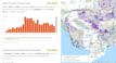 This dataset presents the information on forest-related greenhouse gas emissions in Cambodia between 2001 to 2024. The data were downloaded from Global Forest Watch and subseque...
-
Plantations in Cambodia by provincial level
Cambodia
April 8, 2026
Source: Global Forest Watch:...
 This dataset shows the extent of tree plantations by species or type within Cambodia at the provincial level in 2000. It includes planted forests and agricultural tree crops est...
-
Tree cover by land cover class in Cambodia 2020
Cambodia
April 8, 2026
Source: Global Forest Watch: https://gfw.global/LCQlwv
 This dataset contained information about tree cover by land cover class in Cambodia in 2020. The data were downloaded from Global Forest Watch and subsequently uploaded to the O...
-
Forest cover loss from fire
Cambodia
April 6, 2026
Source: Global Forest Watch:...
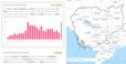 This dataset presents information on forest cover loss caused by forest fires in Cambodia from 2001 to 2024. The data were downloaded from Global Forest Watch and subsequently u...
-
Forest cover data
Cambodia
January 28, 2026
Source: Global Forest Watch:...
 This dataset includes tree cover extent, primary forest extent, aboveground live woody biomass (AGB) stocks and densities, annual tree cover loss, annual tree cover loss by domi...
-
Forest cover in Cambodia (2015-2023)
Cambodia
September 6, 2024
Source: Servir SEA: https://cambodia-me-servir.adpc.net/mapviewer
 Through the implementation of USAID's Supporting Forests and Biodiversity (USAID SFB) ensuring ecological stability and biological productivity for landscape management and cons...
-
Land cover in Cambodia (2015-2023)
Cambodia
December 21, 2024
Source: Servir SEA: https://cambodia-me-servir.adpc.net/mapviewer
 The Cambodia national Land Cover time series (2015-2023) was derived from the Biophysical M&E Dashboard tool, being used by USAID/Cambodia to track performance and report on lan...
-
Land cover in Vietnam 2015 - 2018
 Viet Nam
September 14, 2020
Source: https://www.eorc.jaxa.jp
Landcover dataset 2015 - 2018 in Vietnam is a data set processed from remote sensing images of JAXA space center Japan. The dataset used PALSAR-2 / ScanSAR and MODIS / NDVI mult...
Viet Nam
September 14, 2020
Source: https://www.eorc.jaxa.jp
Landcover dataset 2015 - 2018 in Vietnam is a data set processed from remote sensing images of JAXA space center Japan. The dataset used PALSAR-2 / ScanSAR and MODIS / NDVI mult...
-
Dataset on forest types, its management and governance in Vietnam
Viet Nam
November 2, 2022
Source: http://www.terra-i.org/terra-i/data/data-terra-i_vietnam.html
The dataset is intended to represent the location and information of land cover change detections. This data is the result of a collaborative project between the UN-REDD Vietnam...
-
Forest cover in Cambodia (2015-2018)
Cambodia
June 13, 2018
Source: The forest monitoring system which is the product of collaboration...
 This forest cover is extracted from the Forest Monitoring System (https://rlcms-servir.adpc.net/en/forest-monitor/) which is developed by SERVIR-Mekong and the Global Land Anal...
-
GISTDA Forest Monitoring System (Thailand)
 Thailand
March 20, 2021
Source: GISTDA Forest Monitoring System (gfms.gistda.or.th)
This is the list of web map services layers which is available from GISDTA Forest Monitoring System. Those layers are permanent forests, national parks, forest area, and burning...
Thailand
March 20, 2021
Source: GISTDA Forest Monitoring System (gfms.gistda.or.th)
This is the list of web map services layers which is available from GISDTA Forest Monitoring System. Those layers are permanent forests, national parks, forest area, and burning...
-
Thailand Forest Cover 2020
Thailand
March 19, 2021
Source: Forest Land Management Office (https://bit.ly/30ZiAhz) Royal...
This is the forest cover dataset Thailand from the Royal Forest Department, the Ministry of Natural Resources and Environment (MoNRE).
-
Thailand Permanent Forest
Thailand
February 10, 2021
Source: GISTDA Portal (https://gistdaportal.gistda.or.th/portal/home/)
This dataset indicated Permanent Forest of Thailand
-
Hansen Forest Cover Loss 2000-2019: Thailand, Vietnam, Laos, Cambodia, Myanmar
Cambodia, Lao People's Democratic Republic, Myanmar, Thailand, Viet Nam
January 21, 2021
Source: Hansen, M. C., P. V. Potapov, R. Moore, M. Hancher, S. A....
This update of gross forest cover loss includes new 2019 loss-year and multispectral imagery layers. Relative to the version 1.0 product our method has been modified in numerous...
-
Regional Land Cover
Cambodia, Viet Nam, Lao People's Democratic Republic, Thailand, Myanmar, China
October 27, 2016
Source: GlobCover 2009 (Global Land Cover Map) RELEASED ON 21st December...
The dataset contains a raster version of the GlobCover land cover map produced for the year 2009, clipped to the Greater Mekong Region. The land cover image is derived from the ...
-
Hansen Forest Cover Gain 2000-2012: Thailand, Vietnam, Laos, Cambodia, Myanmar
Cambodia, China, Lao People's Democratic Republic, Myanmar, Thailand, Viet Nam
December 17, 2020
Source: Hansen, M. C., P. V. Potapov, R. Moore, M. Hancher, S. A....
Forest gain during the period 2000–2012, defined as the inverse of loss, or a non-forest to forest change entirely within the study period. Encoded as either 1 (gain) or 0 (no g...
-
Hansen Tree Cover 2000: Thailand, Vietnam, Laos, Cambodia, Myanmar
Cambodia, China, Lao People's Democratic Republic, Myanmar, Thailand, Viet Nam
December 17, 2020
Source: Global Forest Watch / Hansen, M. C., P. V. Potapov, R. Moore, M....
A dataset visualising tree cover across the Greater Mekong Subregion at 30 x 30m resolution. For the purpose of this study, “tree cover” was defined as all vegetation taller tha...
-
Land cover in Cambodia (2012- 2016)
Cambodia
December 15, 2020
Source: Regional Land Cover Monitoring System...
 The land cover is extracted from the Regional Land Cover Monitoring System (https://rlcms-servir.adpc.net/en/landcover/) which is developed by SERVIR-Mekong. The primitives are ...
-
Land cover of Vietnam 2009
Viet Nam
August 31, 2020
Source: Food and Agriculture Organization of the United Nations. FAO...
Dataset is polygon data with geospatial referecing. Land cover maps use as input observations from the 300m MERIS sensor on board the ENVISAT satellite mission. Maps cover perio...